Google this week announced updates to its navigation applications, Google Maps and Waze, aimed at enhancing user safety and improving the overall navigation experience. The tech giant revealed several new features that will be rolled out globally in the coming weeks, addressing key concerns such as incident reporting, destination guidance, and traffic event notifications. These updates reflect Google's ongoing efforts to leverage user-generated data and advanced technology to provide more accurate and timely information to drivers worldwide.
According to Asaf Barzilay, Director of Product at Waze, and Amanda Leicht Moore, Director of Product at Google Maps, the new features are designed to keep users safer and more informed while on the go. The updates come at a time when navigation apps are increasingly relied upon not just for directions, but also for real-time traffic information and safety alerts.
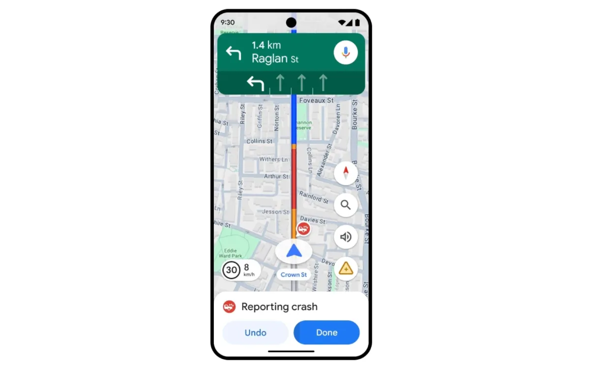
One of the most notable changes is the improvement in incident reporting for Google Maps. The app will now feature larger reporting icons that are easier to tap, allowing drivers to quickly share updates about road conditions, such as construction, lane closures, objects on the road, and police presence. This enhancement aims to streamline the process of contributing valuable information to the community, potentially reducing traffic congestion and improving overall road safety.
The incident reports will be visible to other drivers, who can confirm the information with a single tap. This crowdsourced approach to data collection and verification has been a hallmark of Waze's functionality, and its integration into Google Maps signals a convergence of features between the two platforms. Importantly, users will be able to see which app a report originated from, providing transparency and potentially increasing user trust in the information provided.
Another significant update is the introduction of new destination guidance in Google Maps. This feature will automatically highlight the user's destination building and its entrance as they approach, along with information about nearby parking lots. This enhancement is particularly valuable for drivers navigating to unfamiliar locations or large complexes, where finding the correct entrance or parking area can be challenging, especially in low-light conditions.
Waze users will benefit from new camera alerts, a feature designed to help drivers comply with local traffic laws. The app will now provide notifications about various types of cameras used to enforce traffic regulations, including those monitoring speed limits, red light violations, lane usage (such as bus or carpool lanes), seatbelt usage, and phone use while driving. These alerts are based on a combination of real-world road information and publicly available data from local authorities, updated by the Waze community.
The introduction of a new traffic events feature in Waze aims to provide users with a better understanding of how events like parades, concerts, and sporting events impact nearby traffic. Users who have recently driven through an affected area or have saved places nearby will receive notifications once an event has started. The feature will offer details such as the cause of the event, road closures, and real-time traffic conditions. Additionally, users will be able to easily share this information with friends and family, helping others to better prepare for their journeys.
Lastly, Waze is introducing lock screen navigation for Android devices, with iOS support coming in the fall. This feature allows users to receive navigation guidance, including turn-by-turn directions, real-time traffic updates, and hazard alerts, while their phone remains securely locked. This enhancement addresses both convenience and safety concerns, allowing drivers to access critical information without the need to unlock their devices.
These updates to Google Maps and Waze reflect a broader trend in the navigation app industry towards more comprehensive, real-time information sharing and community-driven data collection. By leveraging the collective knowledge of millions of users, these apps aim to provide a more accurate and up-to-date picture of road conditions and potential hazards.
The integration of features between Google Maps and Waze, both owned by Google, also raises questions about the long-term strategy for these two platforms. While they continue to operate as separate apps with distinct user bases, the increasing overlap in functionality suggests a potential future consolidation or more defined differentiation of their roles within Google's navigation ecosystem.
From a technical standpoint, the implementation of these new features requires sophisticated data processing and machine learning algorithms. The ability to quickly verify and display user-reported incidents, for example, involves real-time data analysis and decision-making processes. Similarly, the new destination guidance feature in Google Maps likely relies on advanced image recognition and geospatial mapping technologies to accurately highlight buildings and entrances.
The introduction of new camera alerts in Waze also presents interesting technical and ethical considerations. While the feature aims to promote compliance with traffic laws, it has the potential to be controversial, particularly in jurisdictions where alerting drivers to the presence of speed cameras or other enforcement measures is discouraged or illegal. Waze's approach of using a combination of community-reported information and publicly available data may help to navigate these concerns, but it remains to be seen how this feature will be received by law enforcement agencies and policymakers.
The lock screen navigation feature for Waze addresses a common user need but also raises potential security concerns. Ensuring that sensitive navigation information is displayed securely while the device remains locked requires careful implementation to prevent unauthorized access to personal data.
As these new features roll out globally, their impact on driver behavior, traffic patterns, and overall road safety will be closely watched by transportation researchers and urban planners. The vast amount of data generated by millions of users could provide valuable insights into traffic flow, accident hotspots, and the effectiveness of various traffic management strategies.
In conclusion, the latest updates to Google Maps and Waze represent a significant step forward in the evolution of navigation applications. By focusing on enhanced safety features, improved community reporting, and more detailed destination guidance, Google aims to provide a more comprehensive and user-friendly navigation experience. As these features become widely available in the coming weeks and months, their real-world effectiveness and user adoption rates will be key indicators of their success.
Key facts about the Google Maps and Waze updates
Announced on July 31, 2024
Larger, easier-to-tap reporting icons added to Google Maps
New destination guidance feature in Google Maps highlights buildings and entrances
Waze introduces new camera alerts for various traffic enforcement measures
New traffic events feature in Waze provides notifications about events impacting traffic
Lock screen navigation introduced for Waze on Android, coming to iOS in fall 2024
Updates to be rolled out globally in the coming weeks
Features leverage community-reported data and publicly available information
Enhancements aim to improve safety and provide more accurate, real-time information
Integration of some features between Google Maps and Waze, while maintaining separate apps
Share this article
The link has been copied!