Gulf of America appears in Google Maps following government database update
Geographic Names Information System changes Gulf of Mexico designation to Gulf of America in U.S. territory digital maps.

Geographic Names Information System changes Gulf of Mexico designation to Gulf of America in U.S. territory digital maps.
A significant modification to digital cartography occurred on January 27, 2025, when Google Maps announced changes to the naming of the Gulf of Mexico within United States territory. According to Secretarial Order 3423, the Geographic Names Information System (GNIS) officially updated the designation to "Gulf of America" in its database.
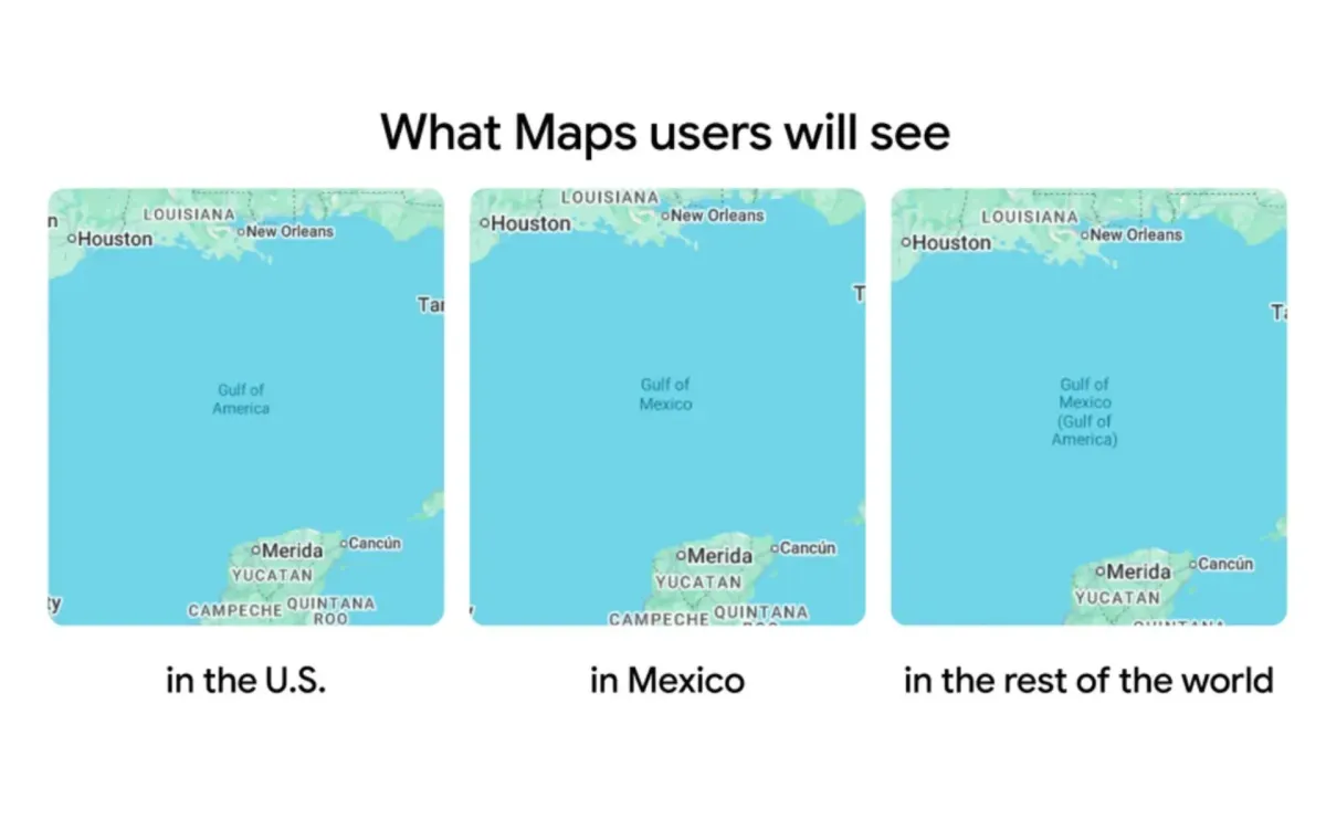
The implementation creates a complex display system based on user location. According to Google's February 10 announcement, users accessing Maps from within the United States now see "Gulf of America," while those in Mexico continue to see "Gulf of Mexico." Users in other global locations view both designations simultaneously.
Technical specifications reveal a sophisticated approach to name display. The system determines user location through multiple data points, including SIM card information, network location, and device locale settings. For web-based users, the displayed name depends on either manually selected regions in search preferences or automatically detected device locations.
The chronology of events shows a methodical implementation process. The initial announcement, made fifteen days ago through Google's official communication channels, outlined the company's established protocols for managing geographic names. According to their statement, these changes align with longstanding practices of updating names when official government sources modify their databases.
Statistical data from the official announcement demonstrates significant public interest. The initial post received 333,500 views, generating 919 direct responses and 1,200 bookmarks on social media platforms. Subsequent technical clarifications about the implementation reached 782,000 views.
Implementation details highlight the technical infrastructure supporting these changes. The system relies on mobile operating systems' location services, with both iOS and Android devices providing essential data determining which geographic names users encounter. This implementation showcases the intricate relationship between government databases, digital mapping systems, and device-level technology.
The U.S. Geological Survey's National Geospatial Program, which maintains the GNIS, serves as the authoritative source for these changes. According to their database update, the modification affects how the body of water appears in official U.S. government documentation and subsequently in digital mapping services.
Social media metrics indicate varying responses to the implementation. The technical explanation post achieved 125,000 views, while the final clarification regarding international naming conventions reached 254,000 views. These numbers reflect substantial public engagement with the geographic name modification.
The changes represent a significant shift in digital cartographic representation within U.S. territory. The implementation maintains different names for the same geographic feature depending on user location, demonstrating the technical complexity of modern mapping systems in managing regional naming variations.
Backend modifications to Google's mapping infrastructure support this implementation. The system simultaneously maintains multiple name variants while ensuring accurate display based on user location. This technical solution involves coordination between database management, user location detection, and interface display systems.
The timing coincides with Google Maps' twentieth anniversary in February 2025, marking two decades of evolution in digital cartography. During this period, the platform has developed increasingly sophisticated methods for handling geographic data and user localization, with this recent change exemplifying the ongoing development of mapping technology.
This modification highlights the intricate relationship between government databases and digital mapping services. The systematic approach to name management demonstrates how geographic information systems adapt to meet various technical and administrative requirements while maintaining consistency with official sources.