Google Maps brings real-time bus tracking to all of England - finally
Google Maps now shows live bus locations across all of England via a UK government-backed deal, ending the guesswork for millions of passengers outside London.

Google Maps now shows live bus locations across all of England via a UK government-backed deal, ending the guesswork for millions of passengers outside London.
Passengers across England can now see exactly where their bus is in real time through Google Maps, following a partnership between Google and the UK Department for Transport (DfT) that went live on Thursday, April 3, 2026. The feature - long familiar to Londoners but unavailable to most of the country - has been extended to cover rural areas and cities alike, giving millions of people live arrival data directly inside an app they already use.
The announcement, made on April 1, 2026 by Kate Alessi, Vice President at Google and Managing Director of Google UK & Ireland, described the collaboration as a step toward making public transport "easier to navigate, more reliable, and simpler to plan," according to her LinkedIn post. Transport Secretary Heidi Alexander, who announced the measure to The i Paper, was equally direct: "Passengers should not be left guessing when their bus will turn up, no matter where they live."
That framing - ending the guesswork - sits at the heart of what the technology actually does. It is less a new product than a data integration. The Department for Transport feeds real-time vehicle location data into Google Maps, which surfaces it to users in the same interface already used for driving, walking, and transit directions. The result is a display that shows whether a bus is on time, delayed, or already at a stop, updated automatically without requiring any action from the user.
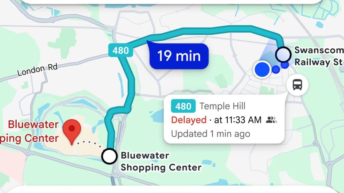
When a user opens Google Maps and requests public transport directions, the app now returns live bus positions alongside standard timetable information. A panel shows the bus route number, expected arrival time, current status - such as "Delayed at 14:01" or "on time" - and when the data was last refreshed. Screenshots released by the Department for Transport show a real-time delay notification alongside a timestamp reading "Updated just now," indicating near-continuous data refresh.
The underlying mechanism resembles what ride-hailing apps such as Uber have used for years. Instead of a fixed timetable that passengers must mentally adjust for disruption, the system tracks the physical position of vehicles and recalculates arrival estimates dynamically. According to The i Paper, the Department for Transport itself drew the comparison to hail-ride apps explicitly, describing the technology as ending the "guesswork" when it comes to catching a bus.
The geo partnerships infrastructure behind this was described by Sarah-Jayne Williams, director of geo partnerships at Google Maps, who said: "By integrating real-time bus information across England into Google Maps, we are giving millions of passengers the confidence to plan their journeys accurately." That statement points to the core technical arrangement: Google is not building new tracking hardware. The bus location data originates with transport operators and is aggregated by or through the DfT before being passed to Google's mapping systems.
This is a meaningful distinction. The quality of the live information depends entirely on how comprehensively operators are feeding position data upstream. Where operators have already implemented GPS-based vehicle tracking - which is widespread in urban areas - the integration should work well. In parts of rural England where smaller operators have older fleets or limited telematics infrastructure, data quality may vary.
The technical announcement does not exist in isolation. England's bus network outside London has been contracting for more than a decade. A 2024 analysis by The i Paper found that cash-strapped councils had been forced to cut a combined 16 million miles of bus routes over the previous 15 years, leaving large numbers of people in rural areas without viable connections to work, healthcare, and services.
Since 2010, bus mileage - the total miles operated by local authorities and commercial operators combined - has fallen by more than 300 million miles, according to government figures cited by The i Paper. The decline coincided with funding reductions that began under the Tory-Lib Dem coalition government, and was deepened by subsequent austerity rounds. The latest available figures show buses ran more than a billion miles in England last year, representing a 2 per cent increase year on year, but that number remains substantially below pre-2010 levels.
The Labour government has sought to address the structural problem with investment: it has committed an extra £3 billion to improving bus services in England and has maintained a fare cap of £3 despite pressure to let fares rise further. Several local authorities have moved to take buses back under public control, with the aim of restoring cut routes. Whether those efforts produce meaningful network recovery will take years to assess.
Real-time tracking improves the experience of using the existing network. It does not restore routes that have been cut. Transport Secretary Alexander acknowledged as much in framing the technology as a step toward a "more joined-up transport network," not as a solution to the coverage gap itself.
One practical challenge sits between the system working technically and working reliably for passengers: mobile network coverage. Real-time data is only useful if a passenger can receive it, and rural England - the area where the new feature is most novel - is also where connectivity is weakest.
A House of Commons report published in December 2025 noted that while 99 per cent of the English landmass has 4G coverage from at least one provider, coverage from all four major operators simultaneously stood at only 88 per cent. The Ofcom Spring 2025 update estimated 5G coverage at 65 per cent of the UK landmass from at least one provider. Coverage from all four at 5G was considerably lower, according to The i Paper.
This matters because a passenger at a rural bus stop may be in an area served by only one operator's signal, and that signal may be intermittent. The live tracking feature requires a data connection to refresh; a cached timetable does not. For the majority of users in urban and suburban areas the connectivity concern is minimal, but in the specific rural context where the extension of this feature is most significant, it represents a genuine constraint.
Transport Secretary Alexander drew attention to one demographic dimension of the rollout that goes beyond general convenience. The ability to know exactly when a bus will arrive - and therefore to time a journey from home to the stop rather than waiting at the stop itself - was cited as having particular relevance for women and girls traveling after dark or at off-peak hours.
Knowing a bus is eight minutes away removes the need to stand at an isolated stop waiting indefinitely. Whether this translates into measurable changes in travel behavior or reported safety perceptions is not something the government has quantified in available documents, but the policy framing reflects a recognition that the experience of waiting for public transport carries different weight for different people.
The social dimension extends to questions about who benefits from a Google-mediated information layer on top of public infrastructure. User reactions on LinkedIn, where Alessi posted the announcement, were broadly positive but included substantive questions. One comment raised concerns about data colonialism. Another noted cycling route inaccuracies in Maps that remain unresolved. A third pointed to persistent issues with incorrect business locations - a user described being directed to a Tesco that sold no petrol and then to a non-existent Shell station. These responses reflect a wider pattern: as Google Maps becomes more embedded in public infrastructure decisions, the platform's existing inaccuracies and data practices attract sharper attention.
Daniel Rubinstein MBCS, commenting on Alessi's post, asked plainly: "Is it the bus being tracked or the people?" That question - whether passenger journey data flows back to Google in ways that go beyond the stated function - was not addressed in the announcement.
For marketers and advertisers, the integration has implications that extend beyond transit. Google's expansion of real-time data integrations with government bodies deepens the platform's role as the primary interface through which people make location-based decisions. Each new data partnership - whether for bus tracking, street imagery, or business profiles - strengthens Google Maps as a destination platform rather than simply a tool.
Gemini now pulls local results directly from Google Maps in visual format, a development from December 2025 that demonstrated how Maps data is becoming a foundational layer for Google's AI products. Grounding with Google Maps in Vertex AI reached general availability in September 2025, connecting developers' AI applications to real-time data from 250 million places worldwide. These moves, taken together with the DfT partnership, show a consistent direction: Google is positioning Maps as infrastructure, not just a consumer app.
For local businesses and advertisers in England, a more actively used Maps platform means more opportunities for discovery through the interface. The transit integration specifically increases the number of journeys that begin as a Maps session - a user checking bus times is also a user who may search for nearby destinations, check business hours, or view location-based advertising. Google already indexes Maps search result pages in organic rankings, a development from August 2025 that shifted how local businesses appear in search.
At the same time, the feature raises the ongoing question of data flows. Google's privacy practices in the UK remain under scrutiny. The company submitted its Q1 2025 Privacy Sandbox report to the UK's Competition and Markets Authority in April 2025, covering commitments made under the CMA's investigation into third-party cookies. The DfT partnership adds a new dimension to that regulatory picture: Google is now a direct partner of a UK government department, handling data about the movement of public transport vehicles across the country.
The rollout of real-time bus tracking in England via Google Maps is not the end of a development process. It is a starting point. The technical integration is live, but its value to passengers will be determined by the quality and completeness of the vehicle data being fed into it, the coverage of mobile networks at the stops where people actually wait, and the reliability with which operators keep their GPS data streams connected and accurate.
The policy ambition is clear: the Labour government wants digital tools to make public transport more competitive with private car travel in a country where bus networks have contracted sharply for fifteen years. The technology can help on the margins, making journeys less uncertain for those who are already using buses. Whether it influences the much harder problem - attracting people back to buses from cars in areas where routes have been cut and journey times have lengthened - is a question the live arrival data alone cannot answer.
What the partnership does demonstrate is that Google is willing and able to negotiate data-sharing arrangements with national governments that extend its mapping infrastructure into public services. That model, once established in one context, tends to expand.
Who: Google, led by UK Managing Director Kate Alessi, partnered with the UK Department for Transport (DfT) and Transport Secretary Heidi Alexander.
What: Real-time bus tracking was integrated into Google Maps across England, allowing passengers to see live vehicle positions, arrival times, and delay information for buses outside London for the first time. The feature works similarly to ride-hailing apps, displaying continuously updated bus locations rather than static timetables.
When: The partnership was announced on April 1, 2026, with the feature going live on Thursday, April 3, 2026.
Where: The rollout covers all of England, including rural areas. It extends a capability that had previously been available only in London to the rest of the country.
Why: The UK government sought to make public transport easier and more reliable to use against a backdrop of more than a decade of bus route cuts outside London. The technology aims to remove uncertainty from bus travel - specifically the need to stand at a stop without knowing when a bus will arrive - with a secondary stated goal of improving confidence and safety for women and girls traveling alone.