Google expands AI-powered Wildfire Boundary tracking to 15 European, African nations
Google's wildfire tracking tool now covers 15 additional countries, providing real-time information to aid safety efforts.

Google's wildfire tracking tool now covers 15 additional countries, providing real-time information to aid safety efforts.
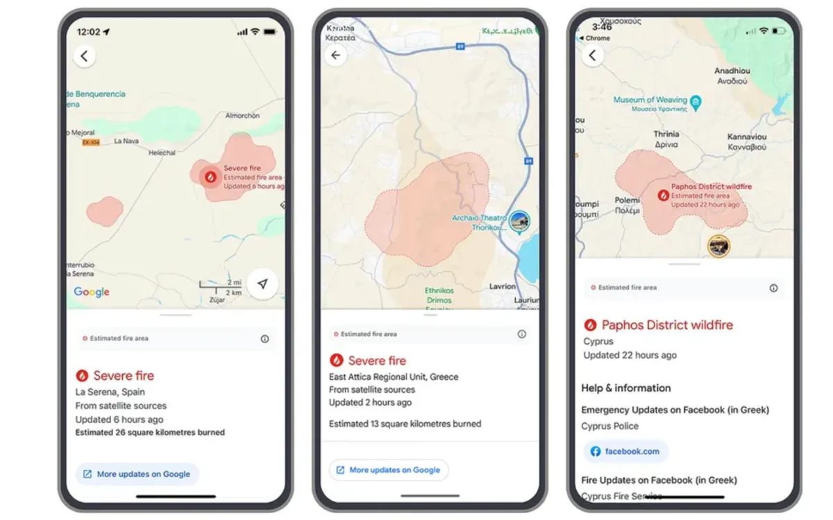
Google this week announced the expansion of its AI-powered wildfire boundary tracking system to 15 new countries across Europe and Africa. This development comes in response to the growing risk of wildfires around the world and aims to provide critical information to communities in fire-prone areas. The expansion, which includes countries such as France, Greece, Spain, and Kenya, represents a significant step in Google's efforts to leverage artificial intelligence for public safety and disaster response.
According to Moriah Royz and Avichai Tendler, Google Research Product Manager and Software Engineer respectively, the expansion of this tool is particularly timely given the recent surge in wildfire incidents across Europe. They cite reports of firefighters battling blazes on Greek islands and in the Spanish community of Extremadura, underscoring the urgency of providing accurate and timely information to affected populations.
The technology behind Google's wildfire boundary tracking is a sophisticated AI model trained on multiple data sources, including various satellite imagery datasets. This model is designed to provide more accurate and definitive wildfire boundaries than traditional methods relying solely on satellite imagery. To ensure reliability, Google validates its wildfire model against a separate AI model that analyzes fire scars—shapes determined after a fire has been contained—based on measurements from past wildfire events.
One of the key features of this system is its ability to surface information through alerts and features that provide safety information to people in proximity to wildfires. This information is made available through Google Search and Maps, as well as through location-based push notifications. The system is designed to be accessible to both native language speakers and visitors who may not speak the local language, a crucial feature during tourist seasons when many travelers may be unfamiliar with local emergency procedures.
The impact of this technology has already been significant. In the first week of July alone, as wildfires broke out across Europe and Africa, Google reports that as many as 1.4 million people accessed their wildfire information. This high level of engagement demonstrates the critical need for such real-time, easily accessible information during emergencies.
From a technical standpoint, the AI model's ability to process and analyze vast amounts of satellite imagery in real-time is a remarkable achievement. The system must contend with challenges such as cloud cover, varying image resolutions, and the dynamic nature of wildfire spread. By combining multiple data sources and employing sophisticated machine learning algorithms, Google's system can provide up-to-date information that complements on-the-ground efforts by local authorities and emergency services.
The integration of this wildfire tracking information into Google Maps driving directions is particularly noteworthy. This feature allows travelers to understand whether their planned routes may be affected by nearby wildfires, potentially preventing dangerous situations and aiding in evacuation efforts. The system's ability to provide this information in the user's preferred language further enhances its utility for international travelers who may be unfamiliar with local emergency protocols.
Google's expansion of this technology to new countries is based on a careful assessment of recent wildfire impacts and the quality of their model in each region. The list of newly covered countries includes Andorra, Bosnia & Herzegovina, Croatia, Cyprus, France, Greece, Italy, Kenya, Monaco, Montenegro, Portugal, Rwanda, Slovenia, Spain, and Türkiye. This expansion adds to the existing coverage in the United States, Canada, Australia, Brazil, Argentina, Chile, and Mexico.
The development of this wildfire tracking system is part of a broader effort by Google to use AI in addressing the impacts of climate change and its associated hazards. As extreme weather events become more frequent and severe due to climate change, tools like this can play a crucial role in disaster preparedness and response.
However, it's important to note that while this technology represents a significant advance in wildfire tracking and information dissemination, it is not a replacement for official emergency services and local authority guidance. Users should always prioritize following instructions from local emergency management agencies during wildfire events.
The expansion of this wildfire tracking system also raises questions about data privacy and the responsibilities of tech companies in emergency situations. While the benefits of such a system are clear, it's crucial to consider how location data is used and protected, especially in the context of emergency notifications.
Looking ahead, Google has expressed hope to expand this feature to more countries as they continue to improve their models over time. This ongoing development could potentially lead to even more accurate and timely wildfire information, further enhancing public safety efforts worldwide.
In conclusion, Google's expansion of its AI-powered wildfire boundary tracking system to 15 new countries in Europe and Africa represents a significant advancement in the use of technology for public safety. By providing real-time, accessible information about wildfire boundaries and potential risks, this tool has the potential to save lives and aid in emergency response efforts. As climate change continues to exacerbate wildfire risks globally, innovations like this will likely play an increasingly important role in disaster management and community safety.
Announced on July 29, 2024
Expanded to 15 new countries across Europe and Africa
Uses AI to analyze multiple satellite imagery datasets
Provides real-time wildfire boundary information through Google Search and Maps
Offers location-based push notifications in users' preferred languages
Integrates wildfire information into Google Maps driving directions
Reached 1.4 million users in the first week of July 2024
Now covers a total of 22 countries worldwide
Part of Google's broader efforts to address climate change impacts using AI
Aims to expand to more countries as model accuracy improves