Google Street View launches in Nepal expanding Himalayan mapping coverage
Google expands Street View technology to Nepal on August 15, 2025, enabling virtual exploration of Kathmandu streets and Himalayan landscapes through 360-degree imagery.

Google expands Street View technology to Nepal on August 15, 2025, enabling virtual exploration of Kathmandu streets and Himalayan landscapes through 360-degree imagery.
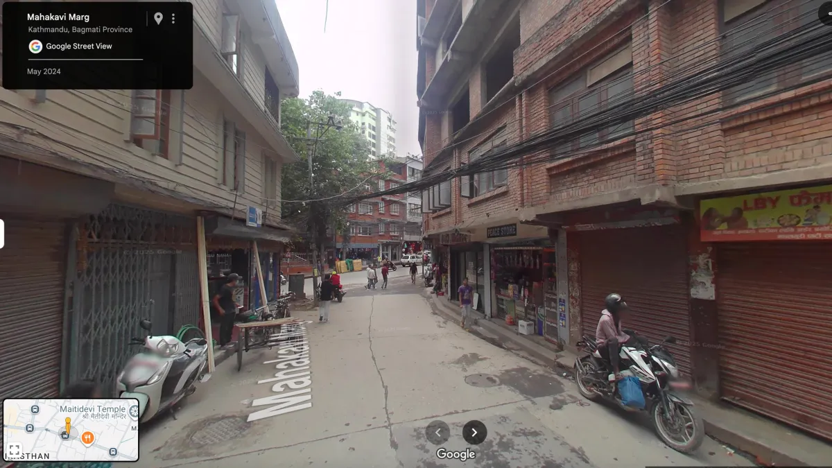
Google announced on August 15, 2025, the launch of Street View services in Nepal, marking the latest expansion of the company's geographic mapping coverage to include the Himalayan nation. According to Google's official blog announcement, users can now virtually explore Nepal's landscapes and cultural sites through interactive panoramic imagery accessible via Google Maps.
The technology rollout encompasses multiple geographic regions within Nepal. "You can now virtually explore the stunning landscapes and vibrant culture of Nepal in Street View," states the official announcement. "Wander the lively streets of Kathmandu, discover the serene beauty of the Terai region or wind along roads that offer breathtaking views of the snow-capped Himalayas — all virtually."
Subscribe the PPC Land newsletter ✉️ for similar stories like this one. Receive the news every day in your inbox. Free of ads. 10 USD per year.
The expansion includes Nepal's capital city Kathmandu, featuring street-level imagery of urban areas, markets, and architectural landmarks. The Terai region, Nepal's southern lowland area, receives coverage displaying agricultural areas and communities. Mountain roads providing access to Himalayan viewpoints now feature 360-degree imagery capturing snow-capped peaks and alpine terrain.
Cultural and historical sites represent a significant component of the Nepal Street View deployment. According to the announcement, users can "immerse yourself in Nepal's rich architectural history, ancient temples and bustling markets." This coverage includes religious sites, traditional architecture, and commercial districts throughout the country.
Technical implementation follows Google's established Street View methodology, utilizing specialized camera systems mounted on vehicles, tricycles, and portable equipment for pedestrian areas. The company's data collection process involves capturing overlapping imagery that algorithms stitch together to create seamless panoramic experiences. Users access Nepal Street View content through standard Google Maps interfaces on both mobile devices and desktop computers.
Navigation functionality mirrors Google's global Street View implementation. Users can "open up Maps from your phone or computer, click the 360° view or the yellow Street View pegman and start exploring," according to the technical instructions provided in the announcement. The yellow pegman icon, Google's primary Street View interface element, enables transitions from traditional map views to immersive street-level perspectives.
The Nepal deployment represents part of Google's broader geographic expansion strategy for Street View technology. The service currently operates in 83 countries worldwide, having captured more than 10 million miles of imagery according to Google's 2017 reporting. Nepal joins other South Asian nations including India, Bangladesh, Sri Lanka, and Bhutan in offering official Street View coverage.
Technical specifications for Nepal's Street View implementation likely utilize Google's current-generation camera systems introduced in 2017. These systems employ eight 20-megapixel cameras with specialized configurations for capturing street signage and building details. Two cameras focus specifically on reading street signs and business names, while laser range scanners measure spatial dimensions up to 50 meters at 180-degree angles.
LIDAR scanning technology, mounted at 45-degree angles, captures three-dimensional depth information and positional data. Global Positioning System integration, combined with wheel speed sensors and inertial navigation systems, ensures accurate geographic positioning of captured imagery. This technical infrastructure enables the precise mapping required for Nepal's varied terrain, from urban streets to mountain roads.
Street View deployment in Nepal required specialized equipment for diverse geographic conditions. Google's technical teams likely utilized standard vehicle-mounted camera systems for Kathmandu's urban areas and highway corridors. Mountain regions and pedestrian areas would require Google's Trekker backpack-mounted camera systems, designed specifically for terrain inaccessible to vehicles.
The Himalayan region presents unique technical challenges for Street View implementation. High-altitude environments affect equipment performance, requiring specialized calibration for atmospheric conditions and temperature variations. The mountainous terrain necessitates careful route planning to ensure comprehensive coverage while maintaining safety standards for data collection teams.
Google's announcement coincides with increased focus on emerging market expansion within the company's mapping division. Recent Street View launches have prioritized regions with growing internet connectivity and smartphone adoption. Nepal's expanding digital infrastructure aligns with Google's strategic objectives for geographic coverage expansion.
The timing of Nepal's Street View launch reflects broader patterns in Google's mapping strategy. The company typically announces new country coverage during periods of stable regional conditions and established partnership relationships with local governments. Nepal's inclusion suggests successful completion of necessary regulatory approvals and technical infrastructure assessments.
For digital marketing professionals, Nepal's Street View integration creates new opportunities for location-based advertising and local business discovery. Local businesses can now benefit from enhanced visibility through Street View's integration with Google's advertising ecosystem. Tourism-focused marketing campaigns gain access to immersive content showcasing Nepal's natural and cultural attractions.
The Street View expansion aligns with Google's broader platform developments in location-based services and advertising technology. Marketing professionals operating in travel, tourism, and local services sectors can leverage Street View imagery for campaign development and customer engagement initiatives.
Geographic expansion of Street View typically correlates with increased Google Maps usage and local search activity. This pattern creates opportunities for location-based advertising campaigns and enhanced local business visibility. Nepal's Street View launch positions the country within Google's expanding ecosystem of location-based marketing tools.
The announcement represents Google's continued investment in comprehensive global mapping coverage despite ongoing challenges in the advertising landscape. The company maintains focus on geographic expansion while adapting to evolving digital marketing and privacy requirements.
Privacy considerations for Nepal's Street View implementation follow Google's established protocols. The company employs automated face-blurring technology and license plate obscuration to protect individual privacy. Standard procedures enable users to request removal of inappropriate or sensitive imagery through Google's review process.
The Street View technology provides significant utility for urban planning, tourism development, and cultural preservation efforts in Nepal. Academic researchers and cultural institutions gain access to detailed visual documentation of Nepal's urban and rural environments. Tourism industry professionals can utilize Street View imagery for marketing materials and virtual destination showcases.
Educational applications include virtual field trips and geographic education programs utilizing Nepal's diverse landscapes. Students worldwide can explore Himalayan geography, urban development patterns, and cultural sites through Street View's immersive interface. This educational access supports geographic literacy and cultural understanding initiatives.
Commercial applications extend beyond tourism marketing to include real estate, logistics, and urban development sectors. Street View imagery enables remote property assessment, delivery route planning, and infrastructure analysis. These applications support economic development initiatives throughout Nepal's urban and rural regions.
The technical infrastructure supporting Nepal's Street View requires ongoing maintenance and updates. Google's standard practice involves periodic re-imaging of areas to maintain current visual information. This process ensures accuracy for business locations, infrastructure changes, and seasonal variations in landscapes.
Integration with Google's broader ecosystem enables cross-platform functionality. Street View imagery connects with Google Earth for three-dimensional exploration, Google Search for location-based queries, and Google Ads for location-targeted marketing campaigns. This integration creates comprehensive geographic information systems supporting various commercial and educational applications.
Subscribe the PPC Land newsletter ✉️ for similar stories like this one. Receive the news every day in your inbox. Free of ads. 10 USD per year.
Subscribe the PPC Land newsletter ✉️ for similar stories like this one. Receive the news every day in your inbox. Free of ads. 10 USD per year.
Who: Google's mapping division launched Street View technology in Nepal, enabling virtual exploration for global users while creating new opportunities for local businesses and tourism operators.
What: Street View deployment provides 360-degree panoramic imagery of Kathmandu streets, Terai region landscapes, Himalayan mountain roads, temples, markets, and cultural sites accessible through Google Maps interfaces.
When: The official launch occurred on August 15, 2025, following Google's established pattern of South Asian market expansion and geographic coverage priorities.
Where: Coverage encompasses Nepal's major urban center Kathmandu, the southern Terai region, mountain roads with Himalayan views, and cultural sites throughout the country.
Why: The expansion supports Google's global mapping strategy while providing tourism marketing opportunities, educational resources, and enhanced local business visibility within Nepal's growing digital economy.
Subscribe the PPC Land newsletter ✉️ for similar stories like this one. Receive the news every day in your inbox. Free of ads. 10 USD per year.
Street View Technology: Google's interactive panoramic imaging system that provides 360-degree visual experiences of geographic locations through stitched photography. The technology utilizes specialized camera arrays mounted on vehicles, tricycles, and portable equipment to capture overlapping images that algorithms process into seamless virtual environments. Street View represents a fundamental component of Google's mapping ecosystem, enabling users to virtually navigate streets, explore landmarks, and examine locations with unprecedented detail and accessibility.
Geographic Coverage: The systematic expansion of mapping services across different countries and regions, representing Google's strategy to document global landscapes through comprehensive visual data collection. Geographic coverage involves technical assessments, regulatory approvals, and infrastructure deployment to ensure accurate representation of diverse terrain types and cultural environments. This expansion strategy enables Google to maintain competitive advantages in location-based services while supporting local economic development through enhanced digital visibility.
Camera Systems: Advanced imaging equipment designed specifically for Street View data collection, featuring multiple high-resolution sensors configured to capture comprehensive visual information. Current-generation systems employ eight 20-megapixel cameras with specialized lenses for different capture requirements, including dedicated units for reading signage and architectural details. These systems integrate with GPS technology, LIDAR scanners, and inertial navigation equipment to ensure precise geographic positioning and dimensional accuracy.
Google Maps Integration: The technical architecture that connects Street View imagery with Google's broader mapping platform, enabling seamless transitions between traditional map views and immersive street-level experiences. This integration supports cross-platform functionality across mobile devices, desktop computers, and web applications while maintaining consistent user interface standards. The system enables location-based searches, business discovery, and navigation features that leverage Street View's visual context for enhanced user experiences.
Pegman Interface: Google's distinctive yellow figure icon that serves as the primary user interface element for accessing Street View functionality within Google Maps. Named for its resemblance to a clothespin, Pegman enables users to transition from two-dimensional map views to three-dimensional street-level perspectives through drag-and-drop interactions. The interface element occasionally features themed variations for special events or specific geographic locations, adding contextual elements that enhance user engagement.
Technical Infrastructure: The comprehensive technology stack supporting Street View operations, including data collection equipment, processing algorithms, storage systems, and delivery networks. This infrastructure encompasses vehicle-mounted camera arrays, specialized software for image stitching and geographic positioning, cloud-based storage for massive datasets, and content delivery networks ensuring global accessibility. The technical foundation enables real-time streaming of high-resolution imagery while maintaining performance standards across diverse network conditions.
Tourism Marketing: Digital marketing strategies that leverage Street View imagery to promote destinations, attractions, and travel-related services through immersive visual content. Tourism marketing applications include virtual destination showcases, hotel and restaurant visibility enhancement, and cultural site promotion that enables potential visitors to explore locations before traveling. This approach supports destination marketing organizations and tourism businesses by providing compelling visual content that influences travel decision-making processes.
Cultural Sites: Historic, religious, and architecturally significant locations documented through Street View technology to preserve and share cultural heritage with global audiences. Cultural site documentation includes temples, monuments, traditional architecture, and community spaces that represent Nepal's cultural identity and historical significance. This digital preservation supports educational initiatives, cultural exchange programs, and heritage tourism while ensuring long-term accessibility to important cultural resources.
Local Business Visibility: Enhanced digital presence for businesses through Street View integration with Google's search and advertising platforms, enabling improved discovery and customer engagement. Local business visibility includes street-level imagery of storefronts, interior views for qualifying establishments, and integration with Google Business profiles that support customer decision-making. This visibility enhancement creates competitive advantages for businesses while supporting local economic development through increased customer awareness and accessibility.
Privacy Protocols: Comprehensive procedures and technologies employed to protect individual privacy within Street View imagery, including automated face blurring, license plate obscuration, and user-requested content removal systems. Privacy protocols ensure compliance with global privacy regulations while maintaining the utility and accessibility of Street View content. These systems employ computer vision algorithms to automatically identify and blur sensitive information while providing mechanisms for users to request additional privacy protections when necessary.